
As part of the Covenant of Mayors' pilot programme for Adaptation, the Policy Support Facility, experts Leon Kapetas & Aurelio Escobar are working with the municipality of Cornellà de Llobregat and the Area Metropolitana Barcelona (AMB) in Spain, Cornellà being part of the 36 municipalities of AMB. In this article, they share the work they are doing, developing a proof of concept for “climate itineraries”, which could later be upscaled to other neighbourhoods of the metropolitan Barcelona area.
As summers are getting hotter, it becomes increasingly harder for people to, first, access and then, stay in the areas where they enjoy critical community services such as local schools, the market, the library, the community centre, health centre, sports facilities, and parks. Taking this into consideration, the principle of Cornellà’s climate itineraries is quite simple: to ensure that social infrastructure remains accessible during hot weather, particularly for the most vulnerable.
The municipality strives for year-round equal access to high quality public space and community services, as seen in the photo below.
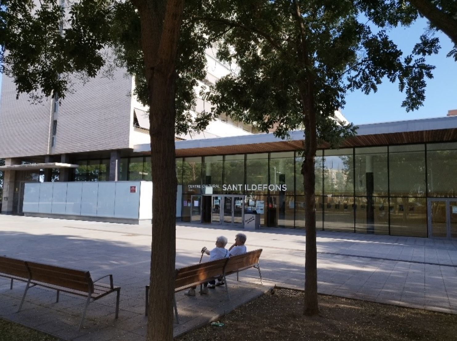
Photo: Seniors enjoying the tree shade in front of the community library of Sant Ildefons, municipality of Cornellà de Llobregat. The library is a Climate Shelter during hot summery days.
The neighbourhood: Sant Ildefons, the most vulnerable
Cornellà opted to test the concept in its most vulnerable neighbourhood, Sant Ildefons. This is a working-class neighbourhood, which was formed by internal migration from Andalusia and Extremadura in the ‘50s and ‘60s but today is also home to thousands of foreign migrants. Its population stands between 25,000 and 30,000 people.
There is a strong sense of community among the residents; the multiple, active community groups are evidence of this. Contrary to other neighbourhoods of Cornellà, San Ildefons is compact with very limited green space. The central square of the neighbourhood is very much are concrete-dominated. At the same time, housing is not fit for today’s hot weather with a large part of the population living in aging “bloques” that have no thermal insulation. These are separated by the “inter-bloques” which also have limited green, as can be seen in the image.
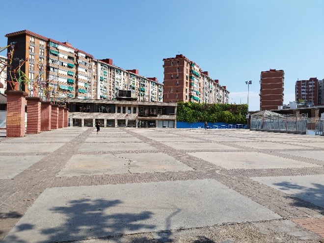
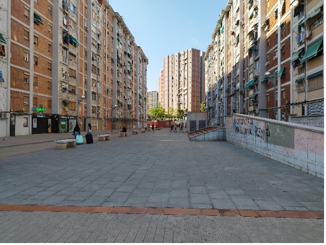
Photos: (Top) Central Square of Sant Ildefons on a summer afternoon; (Bottom) Concrete interbloque: buildings providing shade in the afternoon.
AMB has mapped heat risk for the entire metropolitan area to find that Sant Ildefons is among the top 5 most vulnerable neighbourhoods in the metropolitan area. This is no surprise: hotter summers, extensive hard paved areas using heat-absorbing construction materials, limited air flow due to the building geometry, combined with poorly insulated apartment blocks create unfavourable conditions. On top of that, the AMB also factors in socio-economic and demographic characteristics: large part of Sant Ildefons’ population is low income (i.e. energy poor households) and certain demographic groups run higher heat risk (elderly, children and outdoor workers).
How does Cornellà co-design and implement climate itineraries?
The process can be broken down into 6 steps.
Step 1 - Mapping
We first mapped where the most critical services (points of interest) in the neighbourhood are. These include the community centre, the health centre, the library, the market, the schools, the parks and principal squares. It is important to note that the first three operate as “refugios climáticos”, i.e. air-conditioned climate shelters that citizens can visit during heatwaves.
Step 2 - Drafting Routes for Climate Itinerary
We then identified those routes that can be combined effectively to connect these services. Ideally, these routes should offer opportunities for a safe and pleasant walkable environment. This allowed us to propose a “draft” route of the climate itinerary. We proposed a closed loop of about 1.5 km with some additional axis and branches that target and improve accessibility for more residents.
Step 3 - Engaging stakeholders in route drafting
We engaged extensively with local stakeholders (people that run the social infrastructure and community groups) to validate the relevance of the “draft” climate itinerary and adapt accordingly. We used these engagement activities to invite citizens to a participatory workshop.
Step 4 - Workshop to present & test the draft itinerary
Running the workshop successfully comprises the most critical step of the process. We hosted 30 to 40 citizens (striving for a representative social/demographic sample) to present the draft itinerary and walk it with them. The aim is dual: (i) firstly, understand the frequency and type of use they make of the route and visited spaces, by extension also explore other routes/spaces to which the itinerary can connect to, and (ii) secondly, identify suitable intervention areas and adaptation measures (e.g. fountains, tree planting, shading, benches, sports equipment. These outcomes are reported on a mapping exercise.
Step 5 - Design & Implement Solutions
Only after taking stock from these activities, can one design and implement Nature Based Solutions and other shading features. Expert landscape designers typically lead this process. Activities are planned for the coming 2 to 3 years.
Step 6 - Follow impact adapted routes
Finally, once constructed, Cornellà wishes to validate that these adapted routes and spaces are indeed used and lead to an improved quality of life for Sant Ildefons residents.
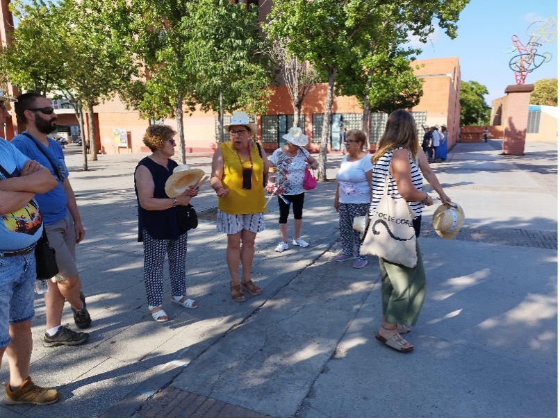
Photo: a group of participants during the walking tour (step 4). They discuss possible changes that can regenerate and cool down the square.
The importance of citizen participation
Participation (step 4) is key for ensuring that interventions (step 5) take place where they are most needed. However, adapting existing uses of public space can create conflict. For instance, the hard-paved central square area is currently used for sports activities (mostly football, excluding other users and uses, giving a gender dimension to the challenge) so any adaptation measure needs to consider this. Similarly, converting car parking to green space needs to be managed carefully and ensure community acceptance. In short, successfully integrating Nature Based Solutions in our built environment is founded on deep, extensive and genuine engagement.
This blog post was written by two experts from our Policy Support Facility programme: Leon Kapetas (Nature Based Solutions expert for the Policy Support Facility of the Covenant of Mayors & Lead for Climate Resilience at the Resilient Cities Network) & Aurelio Escobar (Governance Expert for the Policy Support Facility of the Covenant of Mayors).
Details
- Publication date
- 7 September 2023